Sugarloaf Mountain, located in Dickerson, Maryland, about thirty miles north of Washington, D.C., is not much of a mountain. At only 1,282 feet above sea level, it’s more of a hill — a small hill. But set amid the rolling farmland of northern Montgomery County, it doesn’t look small. In fact, Sugarloaf’s summit is so prominent — and so close to Washington, D.C. — that Franklin Roosevelt considered making Sugarloaf his presidential retreat (before deciding on the nearby Camp David). It was from Sugarloaf that Union troops first spotted the Confederate Army crossing the Potomac River in 1862. I first began to notice Sugarloaf in 2009, on one of my frequent trips to the nearby Dickerson whitewater slalom course. I’d driven past this hill since my first trip to Dickerson years before, but it wasn’t until my fifth year of living in Washington, D.C. that I began to notice it. That fall, as I drove an hour north out of the city and across the flatlands, Sugarloaf — really the closest mountain you hit when driving out of D.C. in any direction, looked taller and taller — and all of a suddenly, I wanted very badly to be on top.

This was a real change for me. I spent most of my life looking down — into river gorges — not up. I wanted to go to the places on the map where the river left the roads and plunged into a canyon so deep that it was like a secret world. These were gorges you had to bushwhack for thirty minutes just to get down to the river — or else you had to own a kayak, in which case you could see the gorge in its entirety. I can’t say if I started kayaking because I wanted to explore these places, or if I wanted to explore these places because I started kayaking. I only know that, when I was 14 years old and had just started boating, every time we drove over the 60-foot bridge on Route 44 bridge near my house in Barkhamsted, Connecticut, I’d look downstream and see two cliffs towering 100 feet over the river and I knew that something about it didn’t look right. It looked more dramatic than the usual rolling hills of western Connecticut. Something had happened to the Earth there, some kind of violence. And I wanted to go down inside and see exactly what it was.
That summer, when I was 14, I did. First I biked the eight miles from my house to the road bridge, and suddenly I found that the rules didn’t apply to me anymore. Just by being curious, I could stash the bike, step over the fence, and scramble down inside. Five minutes later I found myself at the bottom, staring at a river rapid right underneath the bridge I’d driven over all my life. It was incredible. That day I walked the length of the gorge on shore, checking all the rapids. A few weeks later I recruited a friend, launched his stepfather’s kayaks into the Farmington River just upstream, and kayaked the length of the gorge. It was the first of many, many river gorges on which I repeated, in some version, these same events.
“I’ve got to see what’s in there”: I found myself thinking this a lot. I found myself driving over a lot of bridges and saying this. There were the river gorges that were famous because you could look down into them from above, like Vermont’s Quechee Gorge, or West Virginia’s New River Gorge, whose famous 876-foot tall highway bridge (third highest in the U.S.) hosts a yearly Bridge Jump Day for base jumpers, and whose 1,700-foot steel arch spans directly above the final whitewater rapid in the eight-mile long gorge. I passed underneath this bridge many times:

Later, when I was 17, I was driving through Vermont with my parents, heading up into the mountains when we crossed a bridge and I saw a river skating down out of a gorge above. We turned the corner and began climbing. Somewhere off to my left I could tell there was a deep, deep gorge, and I knew there were all kinds of secret waterfalls down inside. Even though I barely knew what town we were in, and even though I had only just purchased my first kayak, I knew that some day I’d have to come back to this place and explore that gorge — either by foot or by boat. Little did I realize I’d stumbled across one of the deepest, most spectacular river gorges in New England, that one day I would go to college just a few miles away, and that once there I’d read the following words in a short outdoor guide written by an expert kayaker about the place:
“This area is isolated from the masses because of the steep canyon walls and rugged whitewater. The only way to get into the gorge is by kayak. Any paddler wishing to attempt this stretch, must be confident boat scouting Class V whitewater. Once you enter the depth of the gorge, you are fully committed to the entire run. There is no way to portage or shore-scout the three hardest rapids. Stakes are high, but the rewards are immense. Before running the river, it is strongly recommended you contact a local kayaker who has paddled it.“
That was the Middlebury Gorge. What would it be like to be down in there? That need to know, to explore these hidden places for myself, heightened by the excitement and the danger of the rapids, brought me for an entire decade to the lowest, most hidden places on the map. It was the bottom of the Earth that called to me, not the summits.

So, when I began to drive past Sugarloaf Mountain in the fall of 2009 and wanted to be on top, it was a new feeling — but it wasn’t until that spring that I thought to actually climb Sugarloaf. That winter, a friend had called with an unusual request: would I like to hike into the Grand Canyon halfway through, join up with his private permit trip, and kayak the second half of the Canyon with them?
“There is a catch,” he told me. “When you hike in, you have to carry your boat.”
Having been forced to pass up at least five such invitations to the country’s most coveted (and permit-only) river, I immediately said yes, despite the strange request, and set about constructing a boat-carrying system. That spring, after fine-tuning a set-up of car tie-down straps and well-placed squares of minicell foam, I began testing the system. I did this the only way I knew how: actual simulation. I roped the boat onto my shoulder and began hiking eight mile loops on the biggest mountain I knew of within an hour of my D.C. home: Sugarloaf.
It was exhilarating. Even though, with a thirteen foot fiberglass kayak strapped to my shoulder I got a lot of weird looks — there was something about working my way up the trail to the top of Sugarloaf and looking out at the roads I’d driven for years that satisfied a need I didn’t even know that I’d had. Even after I ironed out the boat carrying system and had long since packed and shipped my boat to Arizona, I kept right on driving out to Sugarloaf and hiking up.
Now a lot of people hike for the exercise. Not me. (At least not back then.) You can drive up most of Sugarloaf to a parking lot — and I often did this, and then I’d walk a comically short distance to the summit — the sort of route intended for mothers pushing strollers, or for men just recovering from gun-shot surgery. I was definitely not interested in earning my views. It wasn’t really about that at all.
But there was something about being up above it all that really felt good after six years of living in a particularly low-lying city (actually a giant swamp). I would marvel, driving around Washington, at how, even in this giant swamp how what little miniscule rises there were commanded majestic real estate prices. All of these pathetic little changes in elevation (Cathedral Heights, the Virginia side of the Potomac near Chain Bridge) were loaded with mansions and dignitaries, but none would even have qualified as a hill in New England. I also remember being frustrated, without really knowing it, by the lack of perspective in such a flat city. It sounds strange, but I never felt as though I could get a handle on where everything in Washington was because I could never get up high enough to see it all. And that’s what it was, I think, that was driving me to Sugarloaf that spring: suddenly, for the first time in my life, I wanted to get high. Or not get high so much as get high up.
What is it about being up high that is so exciting — and what makes it different from the desire to go to the bottom of a river gorge? For one, it’s an Olympic feeling: one of both power and of importance. When we’re standing on the top of Camel’s Hump at the roof of Vermont we are quite literally looking down on everyone and everything. To look down on Interstate 89 and see the microscopic cars racing like insects is to see one’s petty concerns in their proper place.
To be up high is to have perspective. To have clarity. To see the city’s geometric design or to see the interlocking river valleys and mountain peaks is to finally understand the physical layout of the land which defines our daily routines and even our interactions on a large scale just as much as the architecture of buildings does on a small scale. Just as Steve Jobs once designed Apple’s Cupertino headquarters to flush employees into common spaces to foster cross-disciplinary collaboration, so does the wide basin of the Winooski River Valley seem to funnel all of central Vermont into the bowl of Montpelier each morning, in which the state is governed. To see from above is to finally understand. Quite simply, the desire to walk, ride, or fly to the highest places — is the desire not to visit a secret world, but to enjoy a privileged view of our own.
Over the past week, I have especially wanted to get high up.
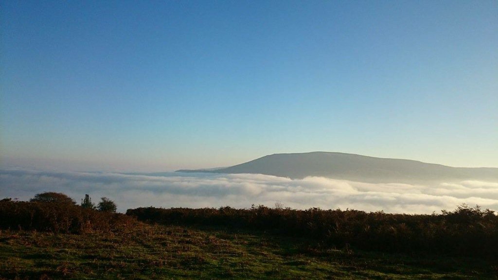
One of the most privileged views afforded to one happens in particular when the weather gods conspire to create a meteorological phenomenon called an inversion. What is an inversion? It is basically when cool air — which is cool enough to form clouds or fog — gets trapped in the valleys by stable, warm air above. As you climb higher, you get warmer. And you also get up above the clouds:
I often check a Facebook group that is devoted to hiking the 4,000 foot peaks of the White Mountains. This past week, conditions were right for hiking above the undercast, and the fact that you can actually do this completely blows my mind. It’s one thing in the Alps, where you’re riding a network of audacious trams for thirty-five minutes up to the types of altitudes where planes require oxygen. But here in New Hampshire? We’d just finished up a dreary, pre-Solstice week of constant dark, and our weather during the day had been defined by constant cloudy skies and light rain — an entire absence of sun for four or five days.
So imagine my surprise to log onto the hiking site one evening this week to see photos from the Presidential Mountains taken on that very day: a whole separate, sunny world up there above the very clouds that had seemed an immutable fact for the past week:

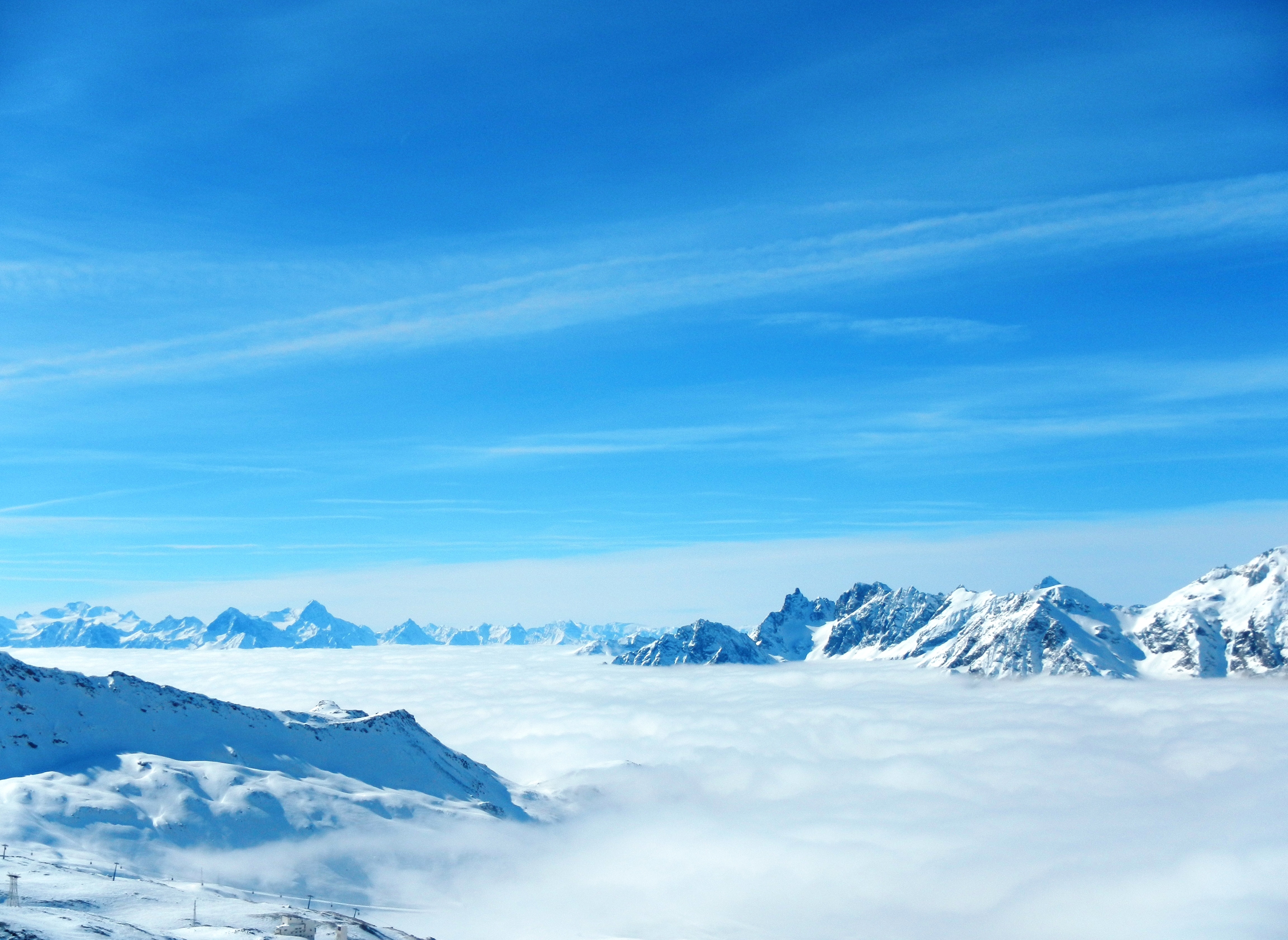
It was only after seeing these photos online this week that I remembered seeing the same types of photos on the same week last year. That weekend, I resolved to hike, ride, or fly high enough to get above the clouds myself. Sure enough, it didn’t take more than a tram ride to the top of Cannon Mountain, where four thousand feet up, I found myself bathed in sunlight above the clouds:
Back when I was a kid, I was a fanatical skier. Nothing angered me more than the type of weather we’re having in New Hampshire right now: a rainy day during ski season. I was always thinking, “If only this rain were snow, we’d be skiing right now!”
Other times, I’d look up at the sky from the rainy, 970-foot summit of our Connecticut ski hill and curse our middling elevation: “But it’s snowing somewhere up there!”
If only we could have vaulted our suburban ski area up a few thousand feet, we’d have reaped the cold temperatures and piles of powder that were, I felt, happening right above us. Now, a few decades later, the same thought had begun to make my Vitamin D-deprived skin crawl: “But it’s sunny somewhere up there!”
A few years ago I took an early morning plane flight out of Burlington, Vermont right around Christmas. “Look!” I said to my fiancee as we got into the sky above Vermont. Though it was only just after six am, during which time I’d normally be driving across points indiscriminate between work and home in the pitch black, there it was out in the distance: the sunrise! We could see — helped by our altitude and by the downhill curve of the Earth (always so very real when see from the sky) — the sun rising far out over the Atlantic, a full hour earlier than we’d have normally seen it.
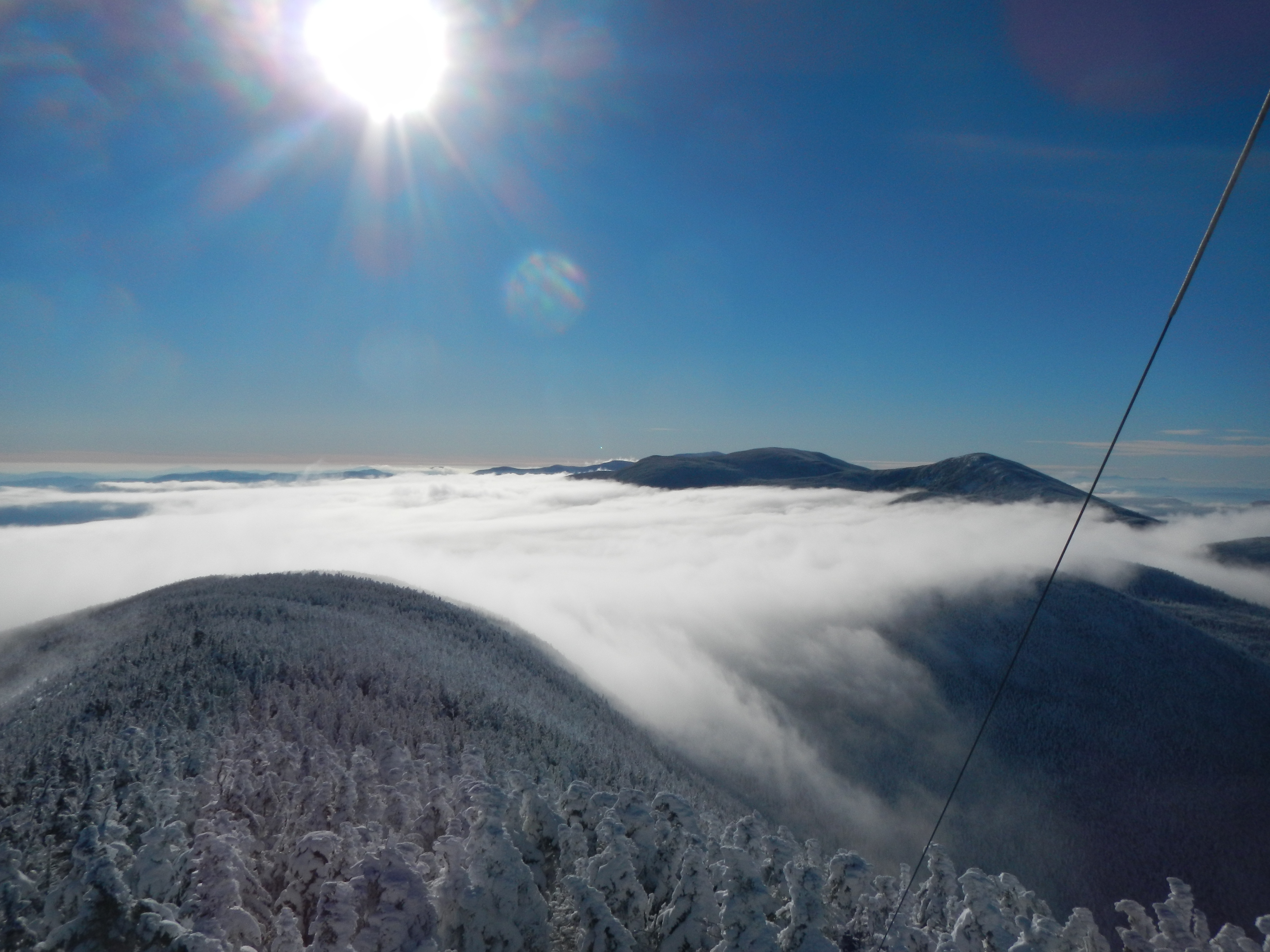
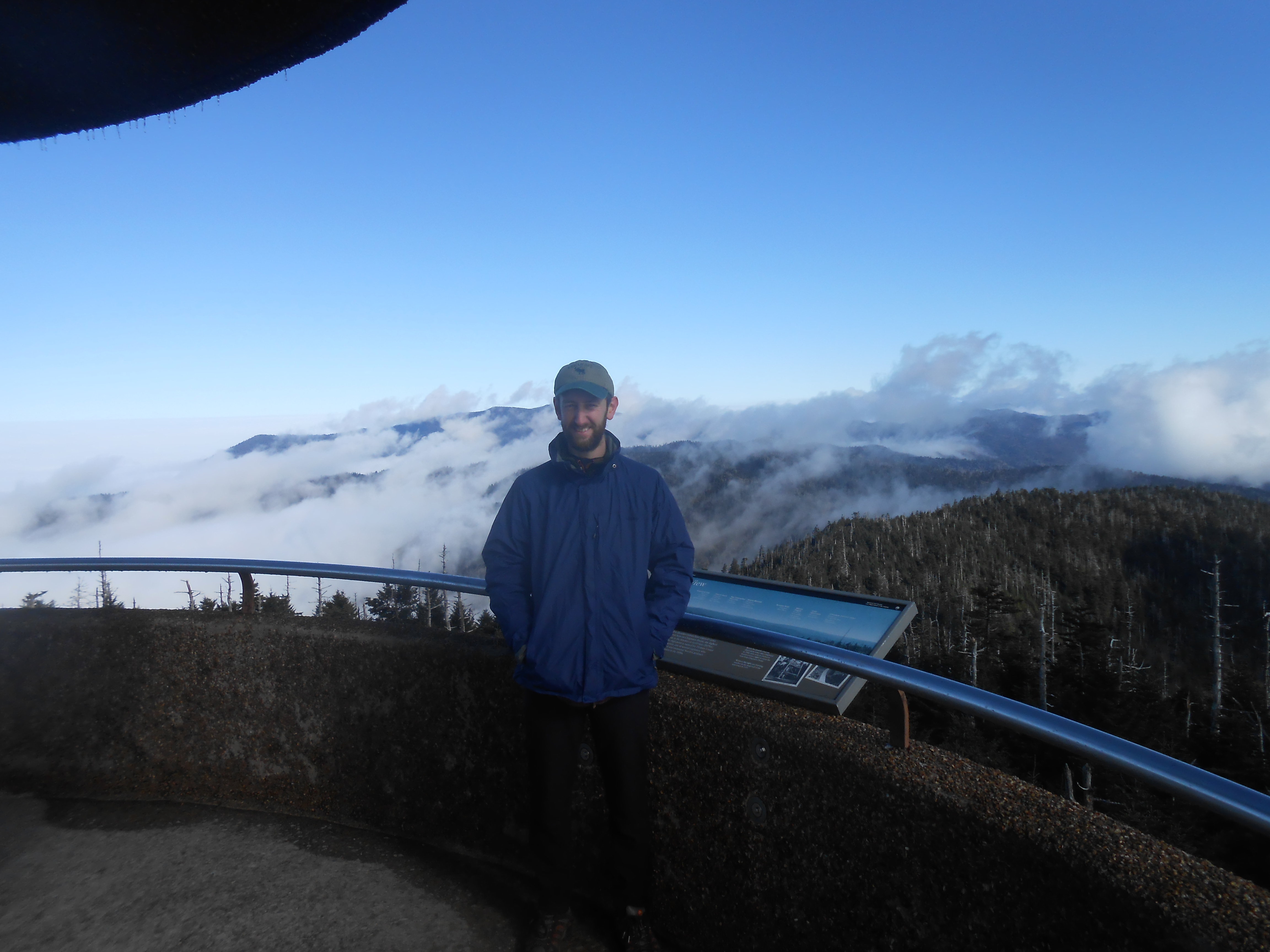
The next winter, last year, we found ourselves retreating south just after Christmas to the relative warmth of the Great Smoky Mountains for a hiking vacation, yet there we encountered a very rare Tennessee snowstorm while driving through perhaps the East’s most garish city. Not very promising for hiking, was it? So imagine our surprise when, hours later, we stood on top of the second-highest point in the eastern United States, Clingman’s Dome, looking out from above the clouds that created the snowstorm:
In the end, I do believe that what led me to the bottom of the river gorges and what nowadays, starting with that small hill back in Maryland, leads me to the mountain summits, are really one in the same. It’s the privileged view. And I’m quite sure that at this time of year — when it’s dark and cloudy and rainy — the most privileged view is the one that brings us up above the clouds, up above all the problems of the world — to the place where it’s always sunny.